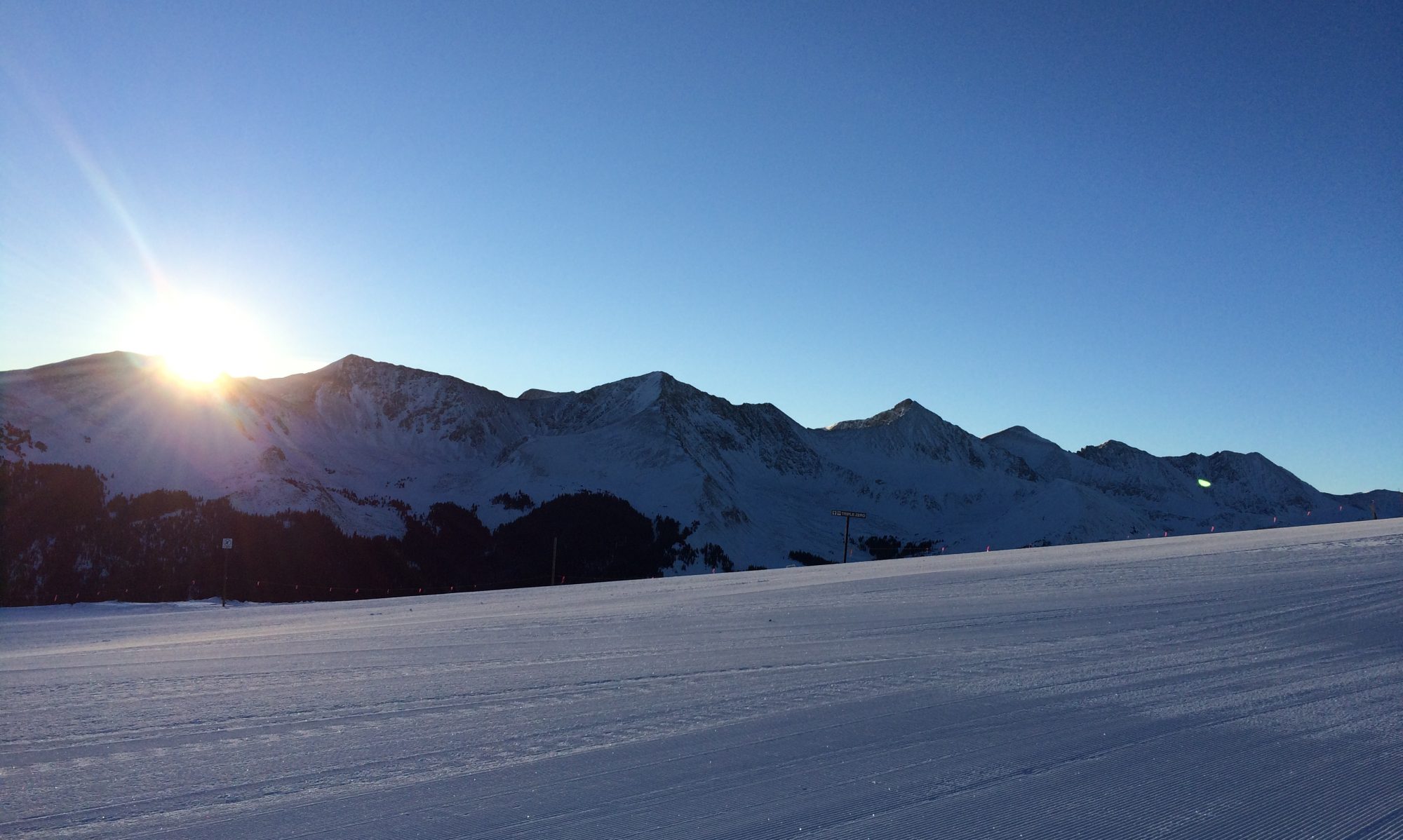
We made it through day 5! Today’s stage took us from Red Cliff to Vail.
The first part of the stage was on a backcountry dirt road. After 8 miles we finally made it to some of the best single track trails we have ever run on. These trails are essentially way in the back of Vail ski area.
The most perfect trails through the forestMore amazing trails
At about mile 14 we made it to the back bowls of Vail. It was really cool to see the area without snow. It’s quite beautiful with tons of wild flowers.
After a bit of running on the ski area access road across the top of Vail we began a long descent down to Vail Village. 24 miles after we started we were finally done and glad of it.
Tonight we are roughing it in a tent on the Ford athletic fields. We have discovered that we are really soft when it comes to camping and that we definitely prefer to sleep indoors. One stage to go.
Reporting from a tent in Vail, Colorado, your tired trainer.
Looking back towards Mt of the Holy CrossBeautiful views as we approach Vail’s back bowlsTime for another selfie!
We made it another day! Today’s stage was on the shorter side at 14 miles and most of the climbing was in the first 6 miles.
We left from Nova Guides and headed out on gravel roads for about 2 miles before beginning the day’s big climb.
The hardest part of the climb was near the top where one segment of the climb gained a bit over 700 feet in 0.7 miles. It was the steepest climb we have done thus far.
The top with beautiful views
After clearing the top we had a bit of flat followed by a long downhill. Near the end of this downhill trail, about the last mile or so, the trail runs through a creek that is flowing rapidly down the hill.
There is no way to avoid getting wet so one just has to get down the creek section as best one can with frozen wet feet. The cold water was nice for about 2 minutes before feet were frozen and numb.
We finished strong into Red Cliff and were looking forward to getting back to the cabin.
Good afternoon all. Today I am writing from a most beautiful cabin at Nova Guides somewhere past Red Cliff, Colorado. Technically I think we are in Camp Hale, which as some of you will know, is where the famed 10th Mountain division of the US Army originally trained for high alpine activities during WWII. It certainly is a pretty spot to train for war.
There are still some old ammo depots and bunker type places lying around the area, but they are more of an interesting attraction than distraction.
Our run today started in a very cold Leadville. If you’d happened to have been driving through Leadville this morning you would have seen all of us runners running along Main Street and out to the highway that leads to Tennessee Pass.
Eventually we turned onto a jeep road and began the biggest climb of the day. It wasn’t too bad, but it certainly got the heart pumping. After about 5 miles we began a descent to mile 8 on more jeep roads.
After some running along a disused paved road we turned onto another jeep road and began another climb. This climb was not particularly steep, but it was a little long. The climb led us to the ski resort called Ski Cooper (no relation to Copper Mountain, much to some tourists’ dismay).
We made a brief stop at the aid station located at Ski Cooper and headed out to finish the last 10 miles of the stage. It was at this point that M pulled out her phone to take pictures as the views were nice. Discovering that her phone was turned off, M turned it on to find that rarest of backcountry beasts, cell service. She also discovered a text message response from the world’s greatest crew chief, sister Sarah! Sarah was responding to M’s earlier request for Larkburger for dinner.
M immediately called Sarah and confirmed that yes, we would like a delivery of burgers and fries for dinner this evening!
After this positive update, our pace picked up a bit because we knew that not only would we be staying in a warm cabin, but we would also be having an awesome dinner.
The last part of the stage was mostly single track with some rolling hills. The trails in this section were very nice trails running through a lovely forest.
After a 3 mile gravel road finish, we were finally done with the day’s 24 miles.
Fortunately we were able to check into our cabin earlier than expected. It was quite a luxury to take a shower in our own bathroom.
Of course it was even nicer when Sarah showed up with our Larkburger order! We had a great dinner with Sarah and we can’t thank her enough for the help she’s given us these last 2 races.
Hoping you all are well and reporting from a cabin nicer than our house, me.
We made it again today. As I said yesterday, today’s run was much more our style. We started in Vicksburg and had about 2 miles of flat, dirt road before beginning the climb up Hope Pass. There were about 3 miles of steep uphill and then around 4-5 miles of downhill. The route finished with a few miles of rolling terrain. Our total for the day was around 13 miles.
We made it to the top!
Hope Pass was beautiful and reminded M and I both more of a European climb than a Colorado climb because of the steepness. It was quite cold at the top so we didn’t linger long before making our way down to the finish at Twin Lakes.
These emails will probably be few and far between due to lack of interweb and the fatigue of the author. Here is a brief update on our first day.
Stage 1 of 6 began in Buena Vista. We ran on a combination of fire roads, dirt roads and single track trail. The weather could not have been better as there were blue skies and the temperature was at most about 70 degrees. The stage was 21 miles long with not much climbing.
M and I both ran well and felt good at the end of the stage.
Tomorrow’s stage is a little more to our liking as it simply goes straight up Hope Pass and then down the other side and is only about 14 miles long. We start in an old mining town called Vicksburg and finish around the Twin Lakes area just outside Leadville.
Reporting from a small cabin in the Arrowhead Point Campground, this is your trainer saying, “Goodnight”.
Going in to the Grand Traversée, M and I expected a tough race and still we got a little more than we bargained for.
As usual I lost contact with M within the first 5 minutes. As it turned out, a lot of people lost contact with M. At one point she was 87th overall and in the top 5 women. There were 570 people in the race. I was doing well and wishing the crowds would thin out a bit so I could make a steady rhythm instead of having to use so much energy passing people.
Some beautiful alphorn music at about mile 3Almost at the top of the first climb
We got a big surprise after completing the first two climbs when we got to what was expected to be a runnable downhill. Instead of being runnable it was the most difficult and technical downhill of the day. Technical downhills would be a theme throughout the day.
From about mile 13-16, I slowed considerably and was the closest I’ve ever been to dropping from a race. I felt horrible and had to hike those three miles of downhill which should have been an opportunity to gain some easy time.
I made it to the next aid station and refueled and somehow got myself going again. By mile 18 I was feeling quite a bit better. I knew that I only had two climbs left till the finish. One from mile 17-24 and the other from mile 32-35. They were both huge climbs but as I had been feeling well on the climbs all day I thought I could make it.
I made it to the mile 24 aid station and again refilled my hydration bladder and other food supplies. As I was on my way down another technical downhill I got an update from M who was at the aid station at Lourtier, at the bottom of the last climb about 5 miles ahead of me. Her time was incredible and was looking to be well ahead of where we thought she’d finish.
I was feeling good and running quite well for most of the section down to the Lourtier aid station, but by the time I got there I was ready for some uphill. The downhill is so hard on your toes! Of course the last uphill was the biggest of the day with 4,000 feet of gain in 3.5 miles! I don’t have any pictures of it because it was getting dark and I was tired.
But here is a picture M took on the last climb
I had a communication from M to take the last climb really slowly because it was so hard, so that is what I set out to do. Most of the climb was so steep you could put your arm straight out in front of you and be touching the section of trail you were going to next.
After cruising relatively quickly (if you can consider 38 minutes per mile quick) up the first 3/4 of the climb I was beset by cramps in my legs. I had to slow considerably but slowing down enabled me to manage the cramps well.
I finally made it to the last aid station at La Chaux thinking M was already finished with the race. As it turned out she had had stomach problems and had only left about 40 minutes before I arrived. I refueled again and set out with my headlight on as it was almost 10 pm.
The last descent in to Verbier was yet another steep technical descent only this time with the added bonus of darkness! M and I had planned to do some night runs before this race in order to practice running with our headlamps, but it didn’t work out so we were in uncharted territory.
The course is well marked with reflective red and white markers so it wasn’t all that difficult to follow. Just not falling off the edge of the trail or tripping over a rock or root was the hard part. Not to mention that by this time our legs were destroyed.
M made her way down and finished in an incredible 11:58! She was the 24th woman overall and 86th overall for men and women combined.
I trudged down to finish in 12:44. I was 228 overall out of 570.
As it turned out, one of the best Ultra runners in the world, a Frenchman by the name of Francois De’Haene, won our race in just over 7 hours.
The race turned out to be about 39 miles with 13,700 feet of gain.
It was even harder than we thought it would be and also more picturesque than we’d imagined.
We are now looking forward to a few days of no running and letting our bodies heal from the beating we took!
Hopefully you all are well and haven’t had too much smoke inhalation.
We have been getting notices of the fire and are hopeful it will be under control soon. The area that is burning is where we did our last big run before going on vacation. It sounds as though it’s now mostly ash and soot which is most unfortunate as that is an excellent trail area.
We are resting hard today in preparation for tomorrow’s big race. We will let you know how we did on Sunday. Stay safe.
Told you our street was a bit steep!Headed down the gondola to Le ChâbleGlaciersAnd we thought the courses at home were hilly. This par 3 course is on a ski slope!
Today has been a day of travel to Verbier. The trip by train from Zermatt to Le Chable was about 3 hours.
Interestingly, when one is traveling in the Zermatt area, the voiceover on the train (not Peyton Manning like at DIA) speaks in German, French and then English. The Zermatt area is mostly German-speaking with French and Italian and English being the other common languages. Once you switch trains at Visp and head towards Martigny, the voiceover on the train switches to French and English only because this part of Switzerland is French speaking.
Eventually the train stops at Le Chable and you get off to take either a bus or gondola up to Verbier. We chose to take the bus because it was sitting right outside next to the train.
The bus route takes you up a many switchbacked road which is very popular with people in fast cars and motorcycles. I saw a Ferrari pass a garbage truck in the middle of a switchback and no one seemed to think this was odd or dangerous.
Verbier is a bigger town than Zermatt and it allows cars which will take a bit of adjusting to. Verbier also has no street signs to tell you which street you are on so finding your lodging is a bit of a guessing game. Fortunately M guessed correctly on her first try.
We thought Zermatt was a steep place to live but it’s nothing compared to Verbier. Since Verbier is on the side of the mountain there are only two ways to go. Up or down.
We will let you know how things are once we get settled.
Our leader thought today would be a good day to rise up (quite literally) against her fear and attempt to conquer the scary trail from Schwarzsee to the Hornli Hutte.
The Hornli Hutte is the starting point for climbing the Matterhorn as should be indicated by some of the pictures below. For mountaineers climbing the Matterhorn, the Hornli Hutte is where they sleep before getting awoken at 3:30 a.m. to begin the climb.
For normal people like us, just getting to the Hornli Hutte is a big challenge. We set off by getting our tickets for the gondola up to Schwarzsee. This started off as a good indicator as M was able to keep her eyes open almost the whole way up the gondola! That never happened a couple years ago when we first went up this particular lift.
We made it up to Schwarzsee with no rookie mistakes, like getting off the gondola too early, and found our starting point. Firstly we had to look straight up the mountain to see where we were trying to get to in 2.5 miles and 2,300 feet of gain however.
It’s a seriously daunting task and the Hutte looks so far away and so high you wonder if the trail really does go up there or if there is some sort of way to magic oneself straight into the Hutte. Then you notice the brightly colored ants marching their way up towards the Hutte and realize they are actually people so it must be possible.
The sign at our starting point says it should take two hours and ten minutes, but that is a really conservative estimate for the slowest people. M and I made really good time until coming to the scary metal walkway that hugs the mountain on one side and has a fairly nasty drop on the other side. M mustered up more courage than ever before (and possibly more curse words) and carefully made her way across the walkway.
After this point the trail gets flat for a little ways until the last half mile when it goes straight up in a series of switch backs on the side of the mountain. We were moving pretty fast, but just to give you an idea of how steep it is, our pace was 70 minutes per mile at this point. That’s right it took us 35 minutes to go half a mile.
Just for some perspective, there is what’s called a Strava segment for the last 1.8 miles of the climb. Strava is an app used by runners and cyclists to store data about their performances. Many top runners use this app so anyone can compare their time on any particular segment to those top runners. M and I were only about 15-16 minutes behind the best mountain runner in the world, Killian Jornet. Search his name on YouTube and you can watch him run up and down the Matterhorn (all the way to the top of the mountain) in under 5 hours I think. M and I finally made it to the Hornli Hutte an hour after starting. We were quite proud of not being too slow!
What goes up must come down however and that means crossing the scary walkway again! With more positive/negative self-talk from M we made it across and had a short celebration before continuing down the hill to our start.
We then rode the gondola back to town and celebrated with Rosti and eggs and ham along with some black cherry gelato! Gotta replace all those calories!
We consider this our biggest adventure ever just because of the difficulties overcoming a serious fear of heights. I am sure it will remain at the top of our list for a long time. Or until Saturday.
We’re heading up to just about where the snow startsAhh! The scenery!That mountain isn’t what should catch your eye – it’s the scary walkway!The Hornli Hutte and the MatterhornThe well-deserved reward
There is not much to report today. M and I decided to take the Gornergrat train all the way to the top of the Gornergrat, which is a bit above where our race finished yesterday.
For those familiar with the show, “The Night Manager,” starring Tom Hiddleston and Hugh Laurie, the Gornergrat is where most of the Zermatt parts of the show were filmed.
Part of the reason we wanted to get back up to the top is that we had run up this mountain back in 2015 as part of the Ultraks race and we remembered the views as being quite striking. During the race 2 years ago we didn’t get much chance to enjoy those views. Hopefully today’s pictures will give some perspective on the drama of the scenery.
We have a fairly big adventure planned for tomorrow so hopefully we will have more pictures to share.